National Register of Historic Places listings in Mercer County, Illinois

This is a list of the National Register of Historic Places listings in Mercer County, Illinois.
This is intended to be a complete list of the properties and districts on the National Register of Historic Places in Mercer County, Illinois, United States. Latitude and longitude coordinates are provided for many National Register properties and districts; these locations may be seen together in a map.[1]
There are 12 properties and districts listed on the National Register in the county. Another property was once listed but has been removed.
This National Park Service list is complete through NPS recent listings posted June 7, 2024.[2]
Map all coordinates using OpenStreetMap
Download coordinates as:
- KML
- GPX (all coordinates)
- GPX (primary coordinates)
- GPX (secondary coordinates)
Current listings
| [3] | Name on the Register | Image | Date listed[4] | Location | City or town | Description |
|---|---|---|---|---|---|---|
| 1 | Commercial House | 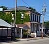 | May 9, 1983 (#83000332) | 5th and Main St. 41°06′03″N 90°56′32″W / 41.1008°N 90.9421°W / 41.1008; -90.9421 (Commercial House) | Keithsburg | |
| 2 | Downtown Aledo Historic District |  | June 7, 2016 (#16000328) | 100-200 blocks N. College, 100, 200, 300 blocks S. College, 100 blk. NW. 2nd, 200 blk. SW. 2nd Aves. 41°12′05″N 90°44′57″W / 41.2015°N 90.7492°W / 41.2015; -90.7492 (Downtown Aledo Historic District) | Aledo | |
| 3 | Gideon Ives House |  | November 8, 2000 (#00001332) | 408 E. Jefferson St. 41°10′10″N 90°59′39″W / 41.1694°N 90.9942°W / 41.1694; -90.9942 (Gideon Ives House) | New Boston | |
| 4 | Keithsburg Historic District |  | May 8, 1986 (#86001004) | Roughly bounded by Jackson, 5th, Washington, and 3rd Sts. 41°06′03″N 90°56′32″W / 41.1008°N 90.9422°W / 41.1008; -90.9422 (Keithsburg Historic District) | Keithsburg | |
| 5 | Lock and Dam No. 17 Historic District |  | March 10, 2004 (#04000177) | 173 Lock and Dam Rd. 41°11′31″N 91°03′29″W / 41.1919°N 91.0581°W / 41.1919; -91.0581 (Lock and Dam No. 17 Historic District) | New Boston | |
| 6 | Mercer County Courthouse | 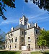 | June 17, 1982 (#82002589) | 100 SE 3rd St. 41°11′58″N 90°44′55″W / 41.1994°N 90.7486°W / 41.1994; -90.7486 (Mercer County Courthouse) | Aledo | |
| 7 | Mercer County Fairgrounds |  | May 2, 1997 (#97000380) | 12th Ave., SW., .5 mi. S of jct. with IL 17 41°11′30″N 90°45′52″W / 41.1917°N 90.7644°W / 41.1917; -90.7644 (Mercer County Fairgrounds) | Aledo | |
| 8 | Mercer County Jail | 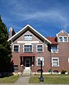 | July 25, 1997 (#97000816) | 309 S. College Ave. 41°11′57″N 90°44′58″W / 41.1992°N 90.7494°W / 41.1992; -90.7494 (Mercer County Jail) | Aledo | |
| 9 | Sherrard Banking Company | 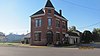 | February 16, 1996 (#96000092) | 314 Third St. 41°19′08″N 90°30′20″W / 41.3189°N 90.5056°W / 41.3189; -90.5056 (Sherrard Banking Company) | Sherrard | |
| 10 | James S. Thompson House |  | December 3, 2002 (#02000846) | 804 North St. 41°10′27″N 90°59′46″W / 41.1743°N 90.996°W / 41.1743; -90.996 (James S. Thompson House) | New Boston | |
| 11 | Verdurette | Upload image | June 17, 2021 (#100005658) | 665 65th Ave. 41°09′59″N 90°57′44″W / 41.1663°N 90.9622°W / 41.1663; -90.9622 (Verdurette) | New Boston | |
| 12 | Levi Willits House | 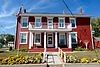 | April 20, 1995 (#95000488) | 202 Main St. 41°10′07″N 90°59′59″W / 41.1686°N 90.9997°W / 41.1686; -90.9997 (Levi Willits House) | New Boston |
Former listing
| [3] | Name on the Register | Image | Date listed | Date removed | Location | City or town | Description |
|---|---|---|---|---|---|---|---|
| 1 | United Presbyterian Church | Upload image | November 7, 1980 (#80001398) | July 17, 1984 | Main and 8th Sts. | Keithsburg |
References
- ^ The latitude and longitude information provided in this table was derived originally from the National Register Information System, which has been found to be fairly accurate for about 99% of listings. Some locations in this table may have been corrected to current GPS standards.
- ^ National Park Service, United States Department of the Interior, "National Register of Historic Places: Weekly List Actions", retrieved June 7, 2024.
- ^ a b Numbers represent an alphabetical ordering by significant words. Various colorings, defined here, differentiate National Historic Landmarks and historic districts from other NRHP buildings, structures, sites or objects.
- ^ The eight-digit number below each date is the number assigned to each location in the National Register Information System database, which can be viewed by clicking the number.
See also
Wikimedia Commons has media related to National Register of Historic Places in Mercer County, Illinois.
- List of National Historic Landmarks in Illinois
- National Register of Historic Places listings in Illinois
- v
- t
- e
- Adams
- Alexander
- Bond
- Boone
- Brown
- Bureau
- Calhoun
- Carroll
- Cass
- Champaign
- Christian
- Clark
- Clay
- Clinton
- Coles
- Cook
- Crawford
- Cumberland
- DeKalb
- DeWitt
- Douglas
- DuPage
- Edgar
- Edwards
- Effingham
- Fayette
- Ford
- Franklin
- Fulton
- Gallatin
- Greene
- Grundy
- Hamilton
- Hancock
- Hardin
- Henderson
- Henry
- Iroquois
- Jackson
- Jasper
- Jefferson
- Jersey
- Jo Daviess
- Johnson
- Kane
- Kankakee
- Kendall
- Knox
- LaSalle
- Lake
- Lawrence
- Lee
- Livingston
- Logan
- Macon
- Macoupin
- Madison
- Marion
- Marshall
- Mason
- Massac
- McDonough
- McHenry
- McLean
- Menard
- Mercer
- Monroe
- Montgomery
- Morgan
- Moultrie
- Ogle
- Peoria
- Perry
- Piatt
- Pike
- Pope
- Pulaski
- Putnam
- Randolph
- Richland
- Rock Island
- St. Clair
- Saline
- Sangamon
- Schuyler
- Scott
- Shelby
- Stark
- Stephenson
- Tazewell
- Union
- Vermilion
- Wabash
- Warren
- Washington
- Wayne
- White
- Whiteside
- Will
- Williamson
- Winnebago
- Woodford

- Bridges
- Houses
- National Historic Landmarks
- Properties of religious function
- Railway stations


