National Register of Historic Places listings in Rock Island County, Illinois

This is a list of the National Register of Historic Places listings in Rock Island County, Illinois.
This is intended to be a complete list of the properties and districts on the National Register of Historic Places in Rock Island County, Illinois, United States. Latitude and longitude coordinates are provided for many National Register properties and districts; these locations may be seen together in a map.[1]
There are 27 properties and districts listed on the National Register in the county, including 1 National Historic Landmark. Another five properties were once listed, but have since been removed.
This National Park Service list is complete through NPS recent listings posted May 31, 2024.[2]
Map all coordinates using OpenStreetMap
Download coordinates as:
- KML
- GPX (all coordinates)
- GPX (primary coordinates)
- GPX (secondary coordinates)
Current listings
| [3] | Name on the Register | Image | Date listed[4] | Location | City or town | Description |
|---|---|---|---|---|---|---|
| 1 | Arsenal Courts Historic District |  | January 6, 2020 (#100004851) | 1400 Fifth St. 41°29′50″N 90°35′30″W / 41.497091°N 90.591737°W / 41.497091; -90.591737 (Arsenal Courts Historic District) | Rock Island | Apartment complex built between 1940 and 1941 by the United States Housing Administration to house defense workers at the Rock Island Arsenal. |
| 2 | Best Building |  | July 17, 2018 (#100002328) | 1701-03 2nd Ave. 41°30′40″N 90°34′33″W / 41.5111°N 90.5758°W / 41.5111; -90.5758 (Best Building) | Rock Island | Renaissance Revival commervcial building constructed in 1908. |
| 3 | Black Hawk Museum and Lodge |  | March 4, 1985 (#85002402) | 1510 46th Ave. 41°27′51″N 90°34′21″W / 41.464167°N 90.572500°W / 41.464167; -90.572500 (Black Hawk Museum and Lodge) | Rock Island | Colonial Revival building that was built as a lodge in a state park. It currently houses the Hauberg Museum. |
| 4 | Black's Store |  | May 28, 1976 (#76000727) | 1st Ave. 41°33′25″N 90°24′51″W / 41.556944°N 90.414167°W / 41.556944; -90.414167 (Black's Store) | Hampton | The largest mercantile store in northwestern Illinois when it opened in the 1840s. The building housed the area's first elevator. |
| 5 | Broadway Historic District |  | August 14, 1998 (#98001046) | Roughly bounded by 17th and 23rd Sts., 5th and 7th Aves., Lincoln Court, and 12th and 13th Aves. 41°30′08″N 90°34′18″W / 41.502222°N 90.571667°W / 41.502222; -90.571667 (Broadway Historic District) | Rock Island | Historic district with more than 550 Victorian homes and other buildings. |
| 6 | Chippiannock Cemetery |  | May 6, 1994 (#94000437) | 2901 12th St. 41°28′54″N 90°34′40″W / 41.481667°N 90.577778°W / 41.481667; -90.577778 (Chippiannock Cemetery) | Rock Island | Almerin Hotchkiss patterned his design on the Rural Cemetery style of Mt. Auburn Cemetery in Massachusetts. It contains monuments by Alexander Stirling Calder and Paul de Vigne. |
| 7 | Connor House |  | August 11, 1988 (#88001227) | 702 20th St. 41°30′18″N 90°34′19″W / 41.505°N 90.571944°W / 41.505; -90.571944 (Connor House) | Rock Island | An early example of the Queen Anne style in Rock Island. The home is located in the Broadway Historic District. |
| 8 | John Deere House |  | February 5, 2003 (#02001756) | 1217 11th Ave. 41°30′06″N 90°31′10″W / 41.501667°N 90.519444°W / 41.501667; -90.519444 (John Deere House) | Moline | The last home owned by inventor and industrialist John Deere. It was built in the Second Empire style. |
| 9 | Denkmann-Hauberg House | 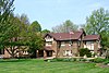 | December 26, 1972 (#72000466) | 1300 24th St. 41°29′33″N 90°34′24″W / 41.4925°N 90.573333°W / 41.4925; -90.573333 (Denkmann-Hauberg House) | Rock Island | Prairie School style home designed by Robert C. Spencer. Home to philanthropists John and Susanne (Denkmann) Hauberg |
| 10 | Downtown Rock Island Historic District |  | March 13, 2020 (#100004433) | Roughly bound by Iowa terminus of the Centennial Bridge a West 2nd St. Davenport, IA, 21st St., 15th St., and 5th Ave. 41°30′36″N 90°34′29″W / 41.509971°N 90.574676°W / 41.509971; -90.574676 (Downtown Rock Island Historic District) | Rock Island | Rock Island's Central Business District, which includes the Centennial Bridge that extends across the Mississippi River into Davenport, Iowa. |
| 11 | Fort Armstrong Hotel |  | November 13, 1984 (#84000327) | 3rd Ave. and 19th St. 41°30′34″N 90°34′23″W / 41.509444°N 90.573056°W / 41.509444; -90.573056 (Fort Armstrong Hotel) | Rock Island | Renaissance Revival luxury hotel from the 1920s. |
| 12 | Fort Armstrong Theatre |  | May 23, 1980 (#80001407) | 1826 3rd Ave. 41°30′36″N 90°34′18″W / 41.51°N 90.571667°W / 41.51; -90.571667 (Fort Armstrong Theatre) | Rock Island | Art Deco movie palace that opened in 1920. |
| 13 | Garfield Elementary School |  | April 10, 2017 (#100000848) | 1518 25th Ave. 41°29′14″N 90°30′53″W / 41.487345°N 90.514734°W / 41.487345; -90.514734 (Garfield Elementary School) | Moline | Neoclassical school building completed in 1902 that is being converted into apartments. |
| 14 | LeClaire Hotel | 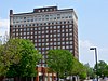 | February 4, 1994 (#94000025) | Junction of 19th St. and 5th Ave. 41°30′31″N 90°30′41″W / 41.508611°N 90.511389°W / 41.508611; -90.511389 (LeClaire Hotel) | Moline | Fifteen-story Renaissance Revival and Commercial-style hotel that opened in 1915. It was the tallest building in the Quad Cities when it opened. |
| 15 | Lock and Dam No. 15 Historic District |  | March 10, 2004 (#04000175) | Northwest of Rodman Ave., Twd., on the northwestern tip of Arsenal Island 41°31′04″N 90°33′58″W / 41.517778°N 90.566111°W / 41.517778; -90.566111 (Lock and Dam No. 15 Historic District) | Rock Island | The largest roller dam in the world. |
| 16 | Lock and Dam No. 16 Historic District |  | March 10, 2004 (#04000176) | 33109 102nd Ave., W. 41°25′46″N 91°00′42″W / 41.429327°N 91.011721°W / 41.429327; -91.011721 (Lock and Dam No. 16 Historic District) | Muscatine | Extends into Muscatine County, Iowa. |
| 17 | Moline Downtown Commercial Historic District |  | August 30, 2007 (#07000856) | Roughly bounded by 12th St. to 18th St., 4th Ave. to 7th Ave. 41°30′25″N 90°30′55″W / 41.506944°N 90.515278°W / 41.506944; -90.515278 (Moline Downtown Commercial Historic District) | Moline | Thirty-three-acre section of the Central Business District in Moline. One hundred buildings contribute to its historical significance. |
| 18 | Old Main, Augustana College |  | September 11, 1975 (#75000673) | 7th Ave. between 35th and 38th Sts. 41°30′15″N 90°32′58″W / 41.504167°N 90.549444°W / 41.504167; -90.549444 (Old Main, Augustana College) | Rock Island | Renaissance Revival building on the campus of Augustana College. It was built from 1884-1893. |
| 19 | Peoples National Bank Building-Fries Building |  | November 22, 1999 (#99001381) | 1729-1731 and 1723-1727 2nd Ave. 41°30′39″N 90°34′30″W / 41.510833°N 90.575°W / 41.510833; -90.575 (Peoples National Bank Building-Fries Building) | Rock Island | Two adjoining commercial buildings in downtown Rock Island. Both were built in the Classical Revival style in the late 19th century. |
| 20 | Potter House |  | May 5, 1989 (#89000364) | 1906 7th Ave. 41°30′18″N 90°34′25″W / 41.505°N 90.573611°W / 41.505; -90.573611 (Potter House) | Rock Island | Colonial Revival residence of newspaper owner Minnie Potter. It is located in the Broadway Historic District. |
| 21 | Rock Island Arsenal |  | September 30, 1969 (#69000057) | Rock Island in the Mississippi River 41°30′58″N 90°32′21″W / 41.516111°N 90.539167°W / 41.516111; -90.539167 (Rock Island Arsenal) | Rock Island | Originally the site of Fort Armstrong, it is now the largest government-owned weapons manufacturing arsenal in the United States. Located on an island in the Mississippi River, it served as a prison camp during the American Civil War. |
| 22 | Rock Island Lines Passenger Station |  | June 3, 1982 (#82002596) | 3029 5th Ave. 41°30′29″N 90°33′20″W / 41.508056°N 90.555556°W / 41.508056; -90.555556 (Rock Island Lines Passenger Station) | Rock Island | A Renaissance Revival style train depot that opened in 1901 and closed in 1980. It now serves as a banquet hall. |
| 23 | Rock Island National Cemetery |  | June 13, 1997 (#97000560) | 0.25 miles north of the southern tip of Rock Island 41°30′46″N 90°31′32″W / 41.512778°N 90.525556°W / 41.512778; -90.525556 (Rock Island National Cemetery) | Rock Island | Established as a national cemetery in 1863 during the Civil War. It also contains a separate cemetery for the Confederate prisoners of war who were held on the island. |
| 24 | Sala Apartment Building |  | August 21, 2003 (#03000782) | 320-330 19th St. 41°30′32″N 90°34′24″W / 41.508889°N 90.573333°W / 41.508889; -90.573333 (Sala Apartment Building) | Rock Island | Renaissance Revival apartment building built in two sections in 1903 and 1913. |
| 25 | Stauduhar House |  | March 5, 1982 (#82002597) | 1609 21st St. 41°29′43″N 90°34′15″W / 41.495278°N 90.570833°W / 41.495278; -90.570833 (Stauduhar House) | Rock Island | Home of Rock Island architect George P. Stauduhar, which he designed in 1895. |
| 26 | Robert Wagner House |  | May 15, 1990 (#90000721) | 904 23rd St. 41°30′08″N 90°34′05″W / 41.502222°N 90.568056°W / 41.502222; -90.568056 (Robert Wagner House) | Rock Island | Classical Revival home of a Rock Island brewer and banker. Built in 1904, it is located in the Broadway Historic District. |
| 27 | Weyerhaeuser House |  | September 11, 1975 (#75000674) | 3052 10th Ave. 41°30′05″N 90°33′19″W / 41.501389°N 90.555278°W / 41.501389; -90.555278 (Weyerhaeuser House) | Rock Island | Rock Island home of lumber baron Frederick Weyerhaeuser. He bought the house in 1865 and extensively renovated it 1882-1883 in the Second Empire style. |
Former listings
| [3] | Name on the Register | Image | Date listed | Date removed | Location | City or town | Description |
|---|---|---|---|---|---|---|---|
| 1 | Joseph Huntoon Homestead | Upload image | May 5, 1978 (#78001182) | September 5, 1986 | 821 16th St. | Moline | Demolished in 1986. |
| 2 | Industrial Home No. 94 | Upload image | November 28, 1978 (#79000866) | May 5, 1981 | 2100 3rd Ave. | Rock Island | Destroyed by fire, December 19, 1980. |
| 3 | Lincoln School |  | August 29, 1985 (#85001910) | January 2, 2020 | 7th Ave. and 22nd St. 41°30′20″N 90°34′09″W / 41.505556°N 90.569167°W / 41.505556; -90.569167 (Lincoln School) | Rock Island | Romanesque Revival school building designed by E.S. Hammatt. It opened in 1893 and ceased being used as a school in 1980. It was located in the Broadway Historic District. It was demolished in 2012.[5]
|
| 4 | General Thomas Rodman House | Upload image | October 3, 1978 (#78001183) | March 16, 1987 | 2532 8½ Ave. | Rock Island | Destroyed by fire, November 7, 1986.[6] |
| 5 | Villa de Chantal Historic District |  | May 22, 2005 (#05000432) | August 28, 2012 | 2101 16th Ave. 41°29′55″N 90°34′13″W / 41.498611°N 90.570278°W / 41.498611; -90.570278 (Villa de Chantal Historic District) | Rock Island | Former Catholic girls school that opened in this location in 1901. Most of the main building was destroyed in a fire in 2005. |
See also
Wikimedia Commons has media related to National Register of Historic Places in Rock Island County, Illinois.
- List of National Historic Landmarks in Illinois
- National Register of Historic Places listings in Illinois
References
- ^ The latitude and longitude information provided in this table was derived originally from the National Register Information System, which has been found to be fairly accurate for about 99% of listings. Some locations in this table may have been corrected to current GPS standards.
- ^ National Park Service, United States Department of the Interior, "National Register of Historic Places: Weekly List Actions", retrieved May 31, 2024.
- ^ a b Numbers represent an alphabetical ordering by significant words. Various colorings, defined here, differentiate National Historic Landmarks and historic districts from other NRHP buildings, structures, sites or objects.
- ^ The eight-digit number below each date is the number assigned to each location in the National Register Information System database, which can be viewed by clicking the number.
- ^ http://www.wqad.com/news/wqad-council-approves-demolition-of-lincoln-school-building-20110920,0,1382899.story
- ^ "Flames wrack Rodman House second time". The Dispatch / The Rock Island Argus. November 7, 1986. p. 1. Retrieved June 21, 2022 – via Newspapers.com.
External links
- Rock Island Historic Structures Inventory
- v
- t
- e
- Adams
- Alexander
- Bond
- Boone
- Brown
- Bureau
- Calhoun
- Carroll
- Cass
- Champaign
- Christian
- Clark
- Clay
- Clinton
- Coles
- Cook
- Crawford
- Cumberland
- DeKalb
- DeWitt
- Douglas
- DuPage
- Edgar
- Edwards
- Effingham
- Fayette
- Ford
- Franklin
- Fulton
- Gallatin
- Greene
- Grundy
- Hamilton
- Hancock
- Hardin
- Henderson
- Henry
- Iroquois
- Jackson
- Jasper
- Jefferson
- Jersey
- Jo Daviess
- Johnson
- Kane
- Kankakee
- Kendall
- Knox
- LaSalle
- Lake
- Lawrence
- Lee
- Livingston
- Logan
- Macon
- Macoupin
- Madison
- Marion
- Marshall
- Mason
- Massac
- McDonough
- McHenry
- McLean
- Menard
- Mercer
- Monroe
- Montgomery
- Morgan
- Moultrie
- Ogle
- Peoria
- Perry
- Piatt
- Pike
- Pope
- Pulaski
- Putnam
- Randolph
- Richland
- Rock Island
- St. Clair
- Saline
- Sangamon
- Schuyler
- Scott
- Shelby
- Stark
- Stephenson
- Tazewell
- Union
- Vermilion
- Wabash
- Warren
- Washington
- Wayne
- White
- Whiteside
- Will
- Williamson
- Winnebago
- Woodford

- Bridges
- Houses
- National Historic Landmarks
- Properties of religious function
- Railway stations


